

You can find on this page the Miami airports map to print and to download in PDF. The Miami airport map presents terminals and gates of the international airport of Miami in Florida - USA.
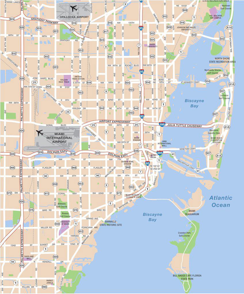
The Miami airports map shows all the airports around Miami. This airports map of Miami will allow you to determine which airport you will used to leave Miami in Florida - USA. The Miami airports map is downloadable in PDF, printable and free.
The Miami International Airport (MIA) and Fort Lauderdale Hollywood International Airport (FLL) are the closest to the city, they are conveniently located on the Miami City bus services, metro, tri-rail and taxi services as its mentioned in Miami airports map. Travel from the airport to the city centre takes no longer and less expensive from both international airports. Most of the domestic and international flights operate from these airports. Another airport that operates in Miami is the Palm Beach International Airport (PBI), which serves the Miami Metropolitan Area. MIA is the major operating airport in the city of Miami, many passengers travel through this airport. It is 13.84 kilometres from the city and has various transport services available round the clock. It takes 30 minutes to reach the city centre.
FLL is the second largest operating airport in the city, serving over 32 million passengers who travel through this airport. Located 50.5 kilometres from Miami city, it has a lot of transport services with round the clock operating hours as you can see in Miami airports map. It is not as close to the city centre as MIA and it takes 47 minutes to reach central Miami. As the second largest operating airport in Miami, Fort Lauderdale Hollywood International Airport serves more than 32 million passengers. Transport facilities charge according to the local government order and theprice of hotels around the airport are affordable. It is a bit far from the city centre but hotels in the city cost more. Airport delay is not more than 15 minutes while security and immigration delay takes more than 20 minutes.
PBI serves over 6 million passengers in and around Miami metropolitan areas. It is located 118.2 kilometres from the city centre making it the farthest among the 3 airports as its shown in Miami airports map. Transportservices are readily available with 24 hour operating hours which takes about 3 hours 30 minutes to reach the city centre. Palm Beach International airport operates only for Miami Metropolitan Areas with more 6 million passengers who travel through the airport. It is very far from the city centre and has fewer transport facilities. Hotel prices are more expensive compared to the other airports. As the less used airport, airport delay is less than 5 minutes while security and immigration delay takes more than 20 minutes.

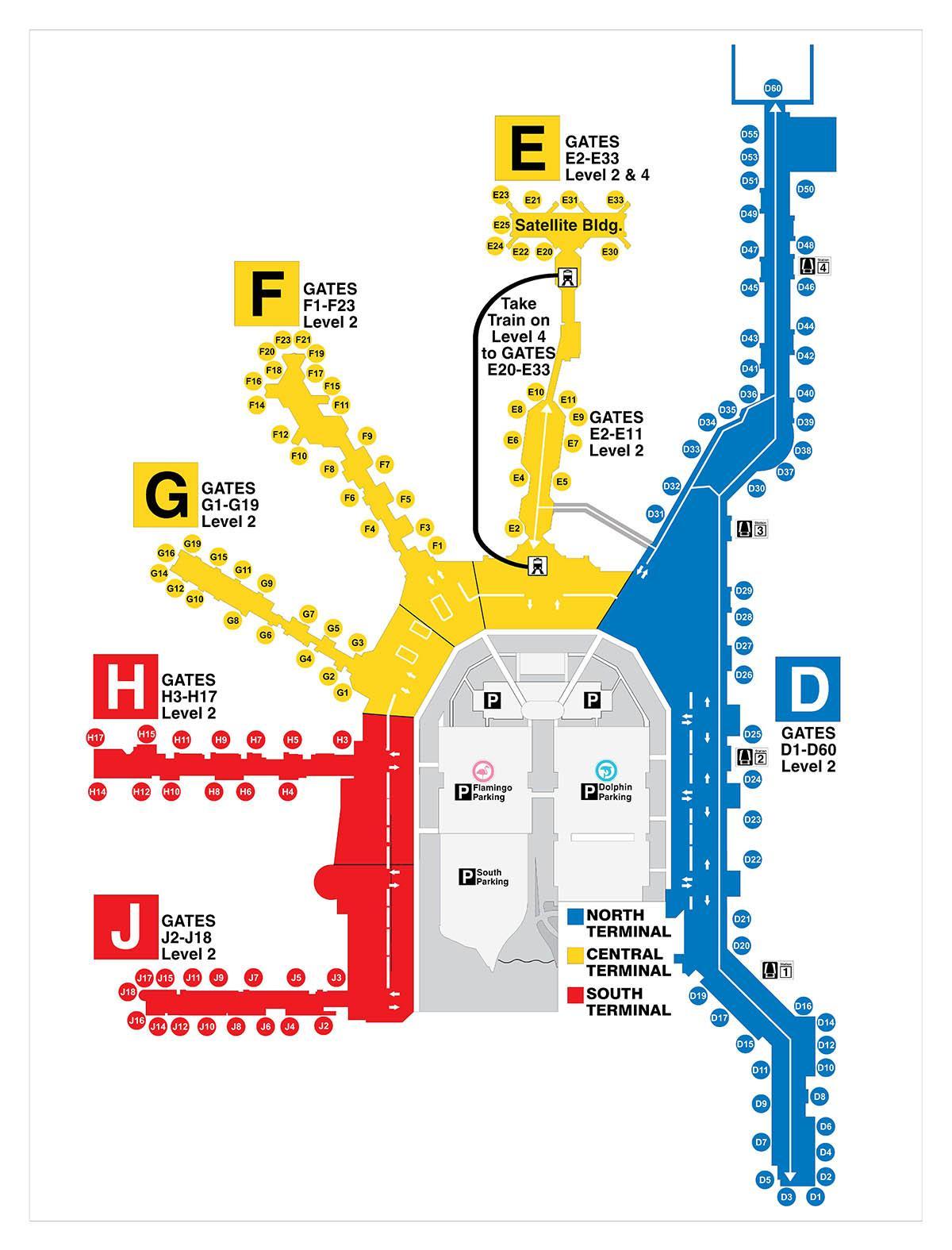
The map of Miami airport presents the main international airport of Miami. This international airport map of Miami will allow you to determine by which terminal and gate you will arrive or leave Miami in Florida - USA. The airport Miami map is downloadable in PDF, printable and free.
Miami International Airport (IATA: MIA, ICAO: KMIA, FAA LID: MIA), also known as MIA and historically Wilcox Field, is the primary airport serving the South Florida area as you can see in Miami airports map. The airport is in an unincorporated area in Miami-Dade County, Florida, eight miles (13 km) northwest of Downtown Miami, in metropolitan Miami, between the cities of Miami, Hialeah, Doral, Miami Springs, the village of Virginia Gardens, and the unincorporated Fountainebleau neighborhood. The airport is a hub for passenger airlines American Airlines, Executive Airlines under the American Eagle name; cargo airlines, UPS Airlines and FedEx Express; and charter airline Miami Air. It is a focus airport for LAN Airlines and its subsidiaries, both for passengers and cargo operations. Miami International Airport has passenger and cargo flights to cities throughout the Americas and Europe, as well as the Canary Islands off the African coast, and cargo flights to Asia; it is South Florida main airport for long-haul international flights.
Miami International Airport is the largest gateway between the United States and Latin America, and is one of the largest airline hubs in the United States, owing to its proximity to tourist attractions, local economic growth, large local Latin American and European populations, and strategic location to handle connecting traffic between North America, Latin America, and Europe as its mentioned in Miami airports map. In the past, it has been a hub for Braniff International Airways, Eastern Air Lines, Air Florida, the original National Airlines, the original Pan Am, United Airlines, and Iberia. Miami International is also the proposed hub of two new start-up airlines, one of which hopes to use the Eastern Airlines name. In 2011 the airport ranked first in the United States by percentage of international flights and second by volume of international passengers, behind only New York-JFK. In 2011, 38,314,389 passengers traveled through the airport, making the airport the 25th-busiest airport in the world by passenger traffic. The Airport also ranks as the 12th busiest airport in the United States by annual passenger count and is the busiest airport in the state of Florida. The airport also handled more international cargo than any other airport in the United States.
The main terminal at MIA dates back to 1959, with several new additions. Semicircular in shape, the terminal has one linear concourse (Concourse D) and five pier-shaped concourses, lettered counter-clockwise from E to J (Concourse A is now part of Concourse D; Concourses B and C were demolished so that Concourse D gates could be added in their place; I was skipped to avoid confusion with the number 1) as its shown in Miami airports map. From the terminal opening until the mid-1970s the concourses were numbered clockwise from 1 to 6. Level 1 of the terminal contains baggage carousels and ground transportation access. Level 2 contains ticketing/check-in, shopping and dining, and access to the concourses. The airport currently has two immigration and customs facilities, located in Concourse E, Level 1 and in Concourse J, Level 3. The Concourse E FIS can be utilized by flights arriving at all gates in Concourse E and most gates in Concourses D (all D gates will be able to route passengers to the FIS by fall 2011) and Concourse F. The Concourse J FIS can be utilized by flights arriving at all gates in Concourse J and most gates in Concourse H. However, all gates in Concourse G and some gates in Concourses D (temporarily), F, and H, do not have the facilities to route passengers to any FIS, and therefore can only be used for domestic arrivals.