

You can find on this page the Miami topographic map to print and to download in PDF. The Miami elevation map present the topography, river and relief of Miami in Florida - USA.

The Miami topographic map shows elevation, hills and landforms in Miami. This elevation map of Miami will allow you to know topography, river and relief of Miami in Florida - USA. The Miami topographic map is downloadable in PDF, printable and free.
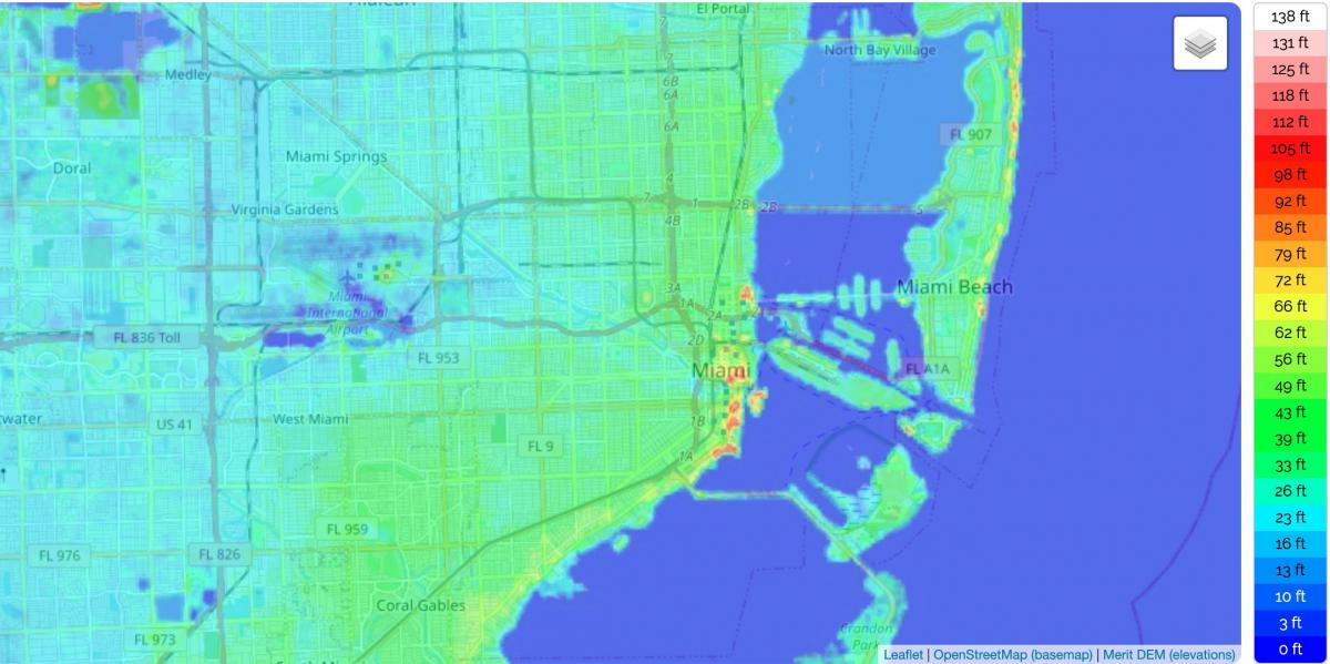
Miami and its suburbs are located on a broad plain between the Florida Everglades to the west and Biscayne Bay to the east that also extends from Florida Bay north to Lake Okeechobee. The elevation of the area never rises above 40 ft (12 m) and averages at around 6 ft (1.8 m) above mean sea level in most neighborhoods, especially near the coast as you can see in Miami elevation map. The highest undulations are found along the coastal Miami Rock Ridge, whose substrate underlies most of the eastern Miami metropolitan region. The main portion of the city lies on the shores of Biscayne Bay which contains several hundred natural and artificially created barrier islands, the largest of which contains Miami Beach and South Beach. The Gulf Stream, a warm ocean current, runs northward just 15 miles (24 km) off the coast, allowing the city climate to stay warm and mild all year.
The surface bedrock under the Miami area is called Miami oolite or Miami limestone. This bedrock is covered by a thin layer of soil, and is no more than 50 feet (15 m) thick. Miami limestone formed as the result of the drastic changes in sea level associated with recent glaciations or ice ages. Beginning some 130,000 years ago the Sangamonian Stage raised sea levels to approximately 25 feet (7.6 m) above the current level as its mentioned in Miami elevation map. All of southern Florida was covered by a shallow sea. Several parallel lines of reef formed along the edge of the submerged Florida plateau, stretching from the present Miami area to what is now the Dry Tortugas. The area behind this reef line was in effect a large lagoon, and the Miami limestone formed throughout the area from the deposition of oolites and the shells of bryozoans. Starting about 100,000 years ago the Wisconsin glaciation began lowering sea levels, exposing the floor of the lagoon. By 15,000 years ago, the sea level had dropped to 300 to 350 feet (110 m) below the contemporary level. The sea level rose quickly after that, stabilizing at the current level about 4000 years ago, leaving the mainland of South Florida just above sea level.
Half the area that surrounds Miami is less than five feet above sea level. Its highest natural elevation, a limestone ridge that runs from Palm Beach to just south of the city, averages a scant 12 feet as its mentioned in Miami elevation map. With just three feet of sea-level rise, more than a third of southern Florida will vanish; at six feet, more than half will be gone; if the seas rise 12 feet, South Florida will be little more than an isolated archipelago surrounded by abandoned buildings and crumbling overpasses. Beneath the plain lies the Biscayne Aquifer, a natural underground source of fresh water that extends from southern Palm Beach County to Florida Bay, with its highest point peaking around the cities of Miami Springs and Hialeah. Most of the South Florida metropolitan area obtains its drinking water from this aquifer. As a result of the aquifer, it is not possible to dig more than 15 to 20 ft (4.6 to 6.1 m) beneath the city without hitting water, which impedes underground construction. For this reason, the mass transit systems in and around Miami are elevated or at-grade. Most of the western fringes of the city extend into the Everglades, a subtropical marshland located in the southern portion of the U.S. state of Florida. This causes occasional problems with local wildlife such as alligators venturing into Miami communities and major highways.