

You can find on this page the Miami buses map to print and to download in PDF. The Miami bus system map and the Miami trolley map present the network, stations and lines of the buses and trolley of Miami in Florida - USA.
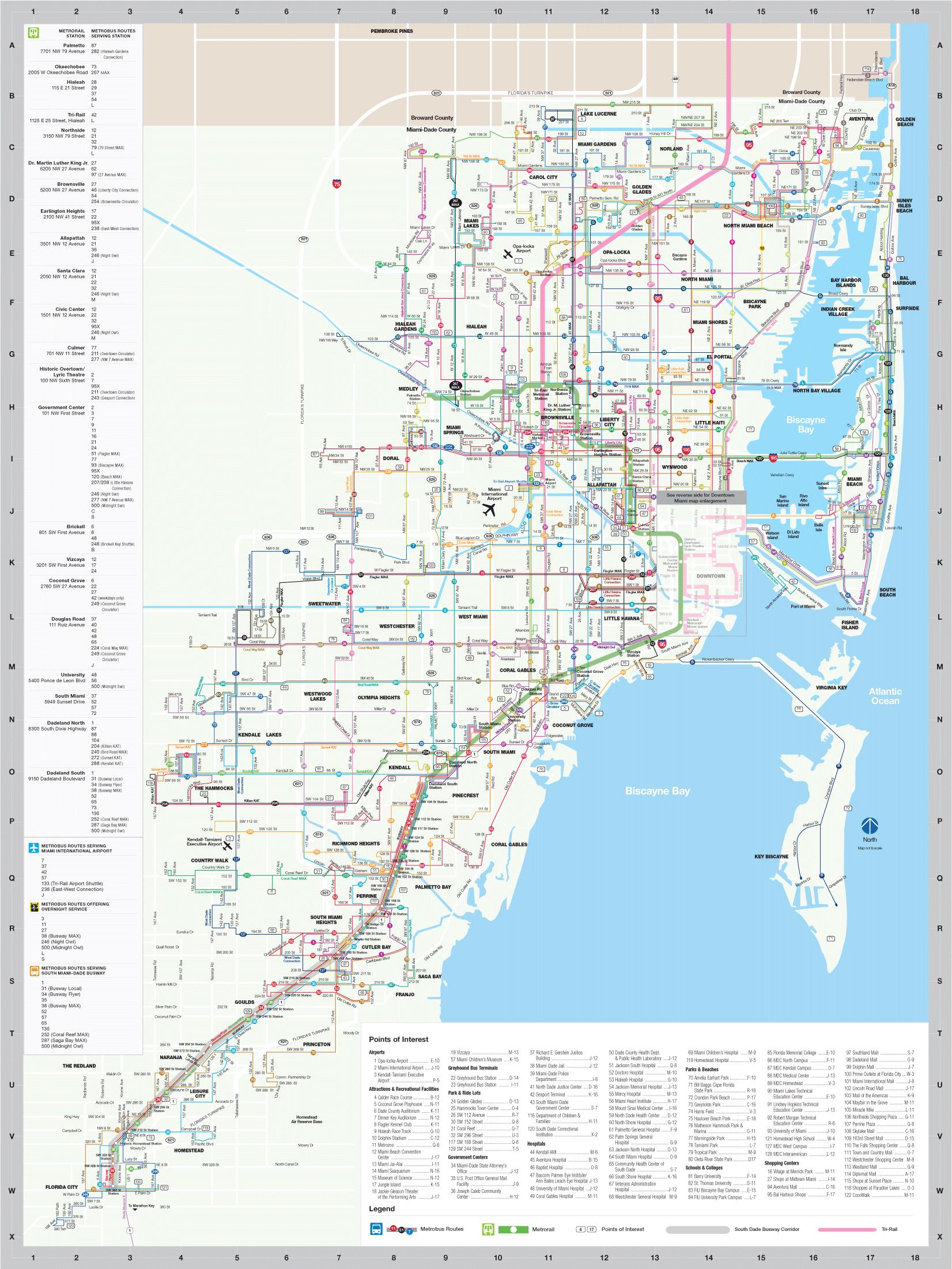
The Miami bus map shows all the stations and lines of the Miami bus system. This bus map of Miami will allow you to easily plan your routes in the buses of Miami in Florida - USA. The Miami bus system map is downloadable in PDF, printable and free.
Over 100 Metrobus routes are operated by Miami-Dade Transit, serving Miami-Dade County, Florida and connecting with several routes in adjacent counties as you can see in Miami bus map. Route termini will be listed in parenthesis along with primary street served, if applicable. Most routes are identified by number or letter, however several others, especially Express, MAX, Shuttle, and Flyer routes do have formal names as well. Routes that are labeled as "Connections" are regular service routes introduced introduced during the 2000s that for the most part are either primarily or were formerly operated by minibuses. Routes labeled as MAX, short for Metro Area Express, are limited stop services. Some routes have branches that carry an "A" or "B" suffix while the "X" suffix denotes an express route, although for the 95X this currently exists only in print. The West Kendall expresses do not use "X" either and instead are labeled as KAT, standing for Kendall Area Transit. Other routes have short turns, these do not carry a suffix.
Lettered Metrobus routes primarily serve Miami Beach, a practice inherited from the Miami Beach Railway Company upon its public takeover in 1962. Increasingly these routes are being referred to by a 100-series number corresponding to that letter position in the alphabet (101-126 except for 104 which is a suburban Kendall route), however it must be noted that presently these numbers only appear online and in customer service applications, and do not appear on printed timetables or on the buses themselves. The will also be shown in parenthesis next to the letter. It is presently not known if a future rebranding of Miami Beach services to numbers may be in the works, however when the former route T was converted into a MAX line in November 2008, it was re-designated as route 120 as its shown in Miami bus map. There was a similar occurrence when MDT took over the South Beach ElectroWave shuttle service in October 2005. It was merged with the similar pre-existing route W, rebranded as the South Beach Local, and given a number of 123. However, this number does not presently appear on the buses or on timetables.
Though it is the biggest and most comprehensive transportation system we have, Miamians have a love/hate relationship with our city buses. The vehicles are clean and air-conditioned but they travel along congested routes and can run on unreliable schedules. The frequency of service varies by route, time and day of the week: as often as every 10 or 15 minutes or as far apart as every 45 minutes as its mentioned in Miami bus map. A one-way bus fare starts at $2.25 and children less than 42 inches tall travel free. Different buses and routes can fluctuate by 25 cents or so, but nothing will cost you more than $3. The bus service intersect with Metromover and Metrorail, serving major entertainment and shopping centers. Riders can pay with an EASY Card or EASY ticket. Riders may also pay the $2.25 trip fare with cash, but no change is given.
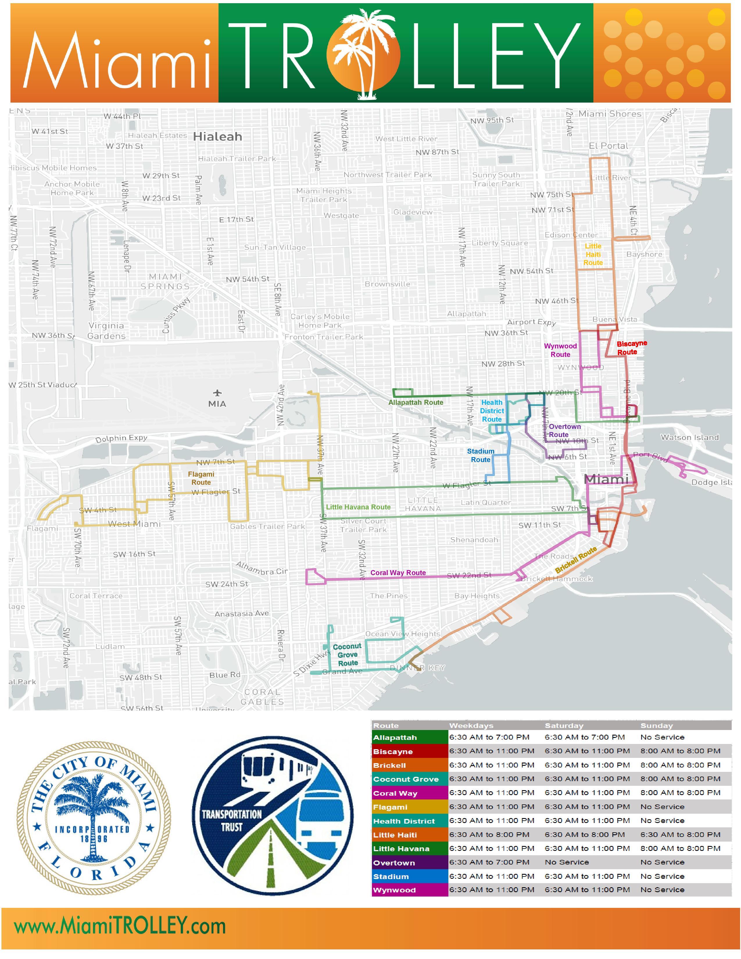
The Miami trolley map shows all the stations and lines of the Miami trolleybus system. This trolley map of Miami will allow you to easily plan your routes in the trolleys of Miami in Florida - USA. The Miami trolley system map is downloadable in PDF, printable and free.
The cities of Miami, Miami Beach and Coral Gables run free trolley service between popular areas and to connect with Metrobus and Metrorail (see Miami trolley map). These can be a great option for traveling to events, such as a gallery, when parking is difficult. The cities often increase trolley service during major events, too. Find the Miami trolleys, the Miami Beach trolleys and the Coral Gables trolley. Not only is traveling by trolley a fun way to explore Miami and Miami Beach, in most neighborhoods - like Miami Beach - it is also free. The free Miami Beach trolley runs Monday to Saturday from 6 a.m. to midnight and Sunday from 8 a.m. to midnight, and with 4 routes to choose from, traveling around Miami Beach South Beach, Mid-Beach , Collins Ave. and North Beach neighborhoods is easier than ever.
The Miami trolley is a great free way to get around certain areas of the city. On the mainland, these orange and green vehicles operate in Allapattah, Downtown, Brickell, Coconut Grove, Coral Way, Edgewater, Little Havana, Overtown, Wynwood and more as its shown in Miami trolley map. There is also a particularly convenient and reliable trolley operating in Miami Beach. Trolley service starts at 6:30am on weekdays and runs till 7pm, 8pm, 11pm or midnight depending on location. You can track the trolley live online. When you see one, you can try to flag it down (they wont stop if they are full) or—the easier option—find a marked stop. When aboard, feel free to ask the driver the best place to get off for your destination.
For visitors to Miami, the most popular trolley routes include the loops around Downtown Miami and Brickell, as well as new routes to Wynwood and the Design District as you can see in Miami trolley map. The air-conditioned trolleys are free and run from 6:30 a.m. to 11 p.m. for most locations. Please see the Miami Trolley Hours of Operation for an exact schedule as it occasionally changes. Sometimes the City of Miami expands the schedule for Miami HEAT games, Art Basel and other special events. The City of Miami Gardens offers three free trolley routes with stops at Hard Rock Stadium, St. Thomas University, and Miami Gardens City Hall, among others. The Miami Gardens trolley runs daily from 7 a.m. to 7 p.m.