

You can find on this page the Miami map to print and to download in PDF. The Miami offline map presents the city center and the location in world map of Miami in Florida - USA.

The Miami map shows the detailed map and a large map of Miami. This map of Miami will allow you to orient yourself in Miami in Florida - USA. The Miami map is downloadable in PDF, printable and free.
The city proper is home to less than 1 in 13 residents of South Florida as its mentioned in Miami map. Additionally, 52% of Miami-Dade County population does not live in any incorporated city. Miami and its suburbs are located on a broad plain between the Florida Everglades to the west and Biscayne Bay to the east that also extends from Florida Bay north to Lake Okeechobee. Miami, city, seat (1844) of Miami-Dade county, southeastern Florida, U.S. A major transportation and business hub, Miami is a leading resort and Atlantic Ocean port situated on Biscayne Bay at the mouth of the Miami River. The Everglades area is a short distance to the west. Greater Miami, the state largest urban concentration, comprises all of the county, which includes the cities of Miami Beach (across the bay), Coral Gables, Hialeah, North Miami, and many smaller municipalities and unincorporated areas; together, these make up the southern section of Florida “Gold Coast”.
The government of the City of Miami (proper) uses the mayor-commissioner type of system. The city commission consists of five commissioners, are elected from single member districts. The city commission constitutes the governing body with powers to pass ordinances adopt regulations and exercise all powers conferred upon the city in the city charter. The mayor is elected at large and appoints a city manager. The City of Miami is governed by Mayor Tomás Regalado and 5 City commissioners which oversee the five districts in the City. It holds regular meetings in the City Hall of Miami located in 3500 Pan American Drive Miami, Florida 33133 in the neighborhood of Coconut Grove on Dinner Key as you can see in Miami map. Miami is home to many entertainment venues, theaters, museums, parks and performing arts centers. The newest addition to the Miami arts scene is the Adrienne Arsht Center for the Performing Arts, the second-largest performing arts center in the United States after the Lincoln Center in New York City, and is the home of the Florida Grand Opera. Within it are the Ziff Ballet Opera House, the center largest venue, the Knight Concert Hall, the Carnival Studio Theater and the Peacock Rehearsal Studio.
Miami has one of the largest television markets in the nation and the second largest in the state of Florida as its shown in Miami map. Miami has several major newspapers, the main and largest newspaper being The Miami Herald. El Nuevo Herald is the major and largest Spanish-language newspaper. Both The Miami Herald and El Nuevo Herald are Miami and South Florida main, major and largest newspapers and are both headquartered in Downtown Miami in Herald Plaza. Miami is also the headquarters and main production city of many of the world largest television networks, record label companies, broadcasting companies and production facilities, such as Telemundo, TeleFutura, Galavisión, Mega TV, Univisión, Univision Communications, Inc., Universal Music Latin Entertainment, RCTV International and Sunbeam Television. In 2009, Univisión announced plans to build new production studios in Miami, dubbed 'Univisión Studios'. Univisión Studios will be headquartered in Miami, and will produce programming for all of Univisión Communications television networks.
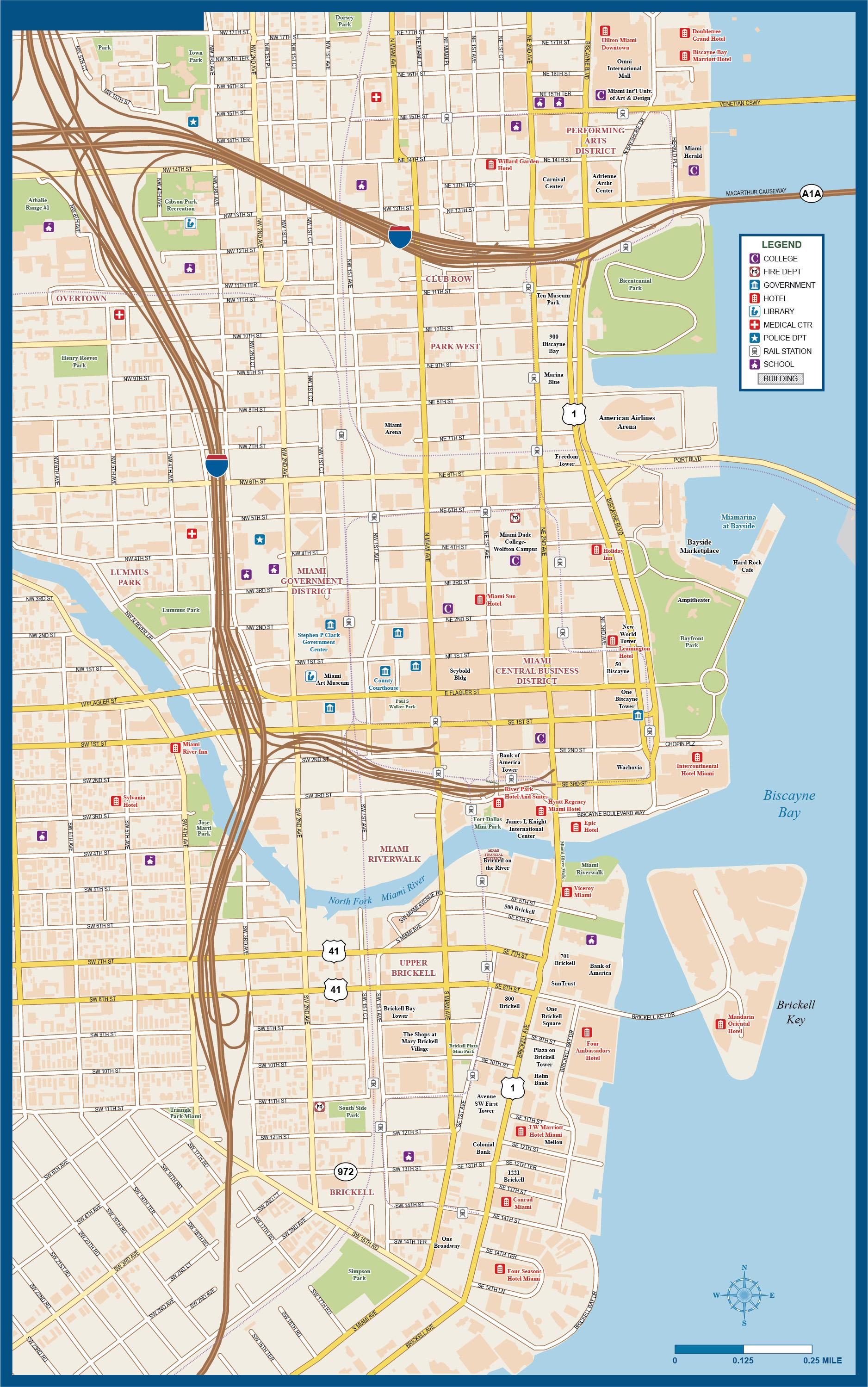
The map of downtown Miami shows the historical center of Miami. This downtown map of Miami will allow you to easily plan your visit in the center of Miami in Florida - USA. The Miami downtown map is downloadable in PDF, printable and free.
Downtown Miami is the central business district of South Florida, Miami-Dade County and Miami, Florida. Brickell Avenue/Biscayne Boulevard is the main north-south road in downtown, and Flagler Street is the main east-west road in the Central Business District as you can see in Miami downtown map. As of 2009, there are approximately 60,000 year-round residents in Downtown (including neighboring Brickell). As of 2009, over 190,000 office employees work in Downtown and Brickell. Downtown, or sometimes referred to as the "Central Business District", is the area north of Broadway, east of I-95, and south of 17th Terrace. Inside of this area includes Park West, the area due west of Bicentennial Park and northern Brickell. Other areas that are many times adjoined with Downtown is the area to the north: Midtown, which is north of 17th Terrace and Brickell to the south.
Downtown is generally and roughly bounded by NE 20th St to the north, Broadway (SE 15th Rd) to the south, Biscayne Bay to the east, and I-95 to the west. The Central Business District, or what is traditionally called "Downtown" is the area north of the Miami River and south of I-395. Within this area, is where the majority of Downtown historical buildings are, the main shopping street, Flagler Street, as well as the vast majority of government offices and courthouses. Although many times labeled under the umbrella term of "Downtown Miami", Brickell and Edgewater are two distinct neighborhoods. Brickell is south of the Miami River, and is a mixed upper-class residential neighborhood as well as Miami major financial district as its shown in Miami downtown map. Edgewater is almost exclusively residential and is north of I-395 bound by Biscayne Bay to the east and NE 1st Ave. However, Edgewater is sometimes labeled as part of Midtown Miami.
As of 2000, Downtown Miami had a population between 11,243 and 13,932 residents, with 6,397 households, and 2,633 families residing in the city. The median household income was $38,702.66. The racial makeup of the neighborhood was 64.27% Hispanic or Latino of any race, 9.17% Black or African American, 23.08% White (non-Hispanic), and 3.49% Other races (non-Hispanic). The zip codes for the Downtown Miami include 33128, 33130, 33131, and 33132. The area covers 2.117 square miles as its mentioned in Miami downtown map. Public transportation in the Downtown area is used more than in any other part of Miami and is a vital part of Downtown life. Metrorail, Miami heavy rail system, makes 3 stops in Downtown at the Historic Overtown/Lyric Theatre Station, Government Center Station, and the Brickell Station. In addition to Metrorail, the Metromover train system runs 3 lines (the Downtown Loop, the Omni Loop, and the Brickell Loop) with 22 stations throughout Downtown. The Metromover is free and stations can be found at roughly every two blocks in Downtown and Brickell.
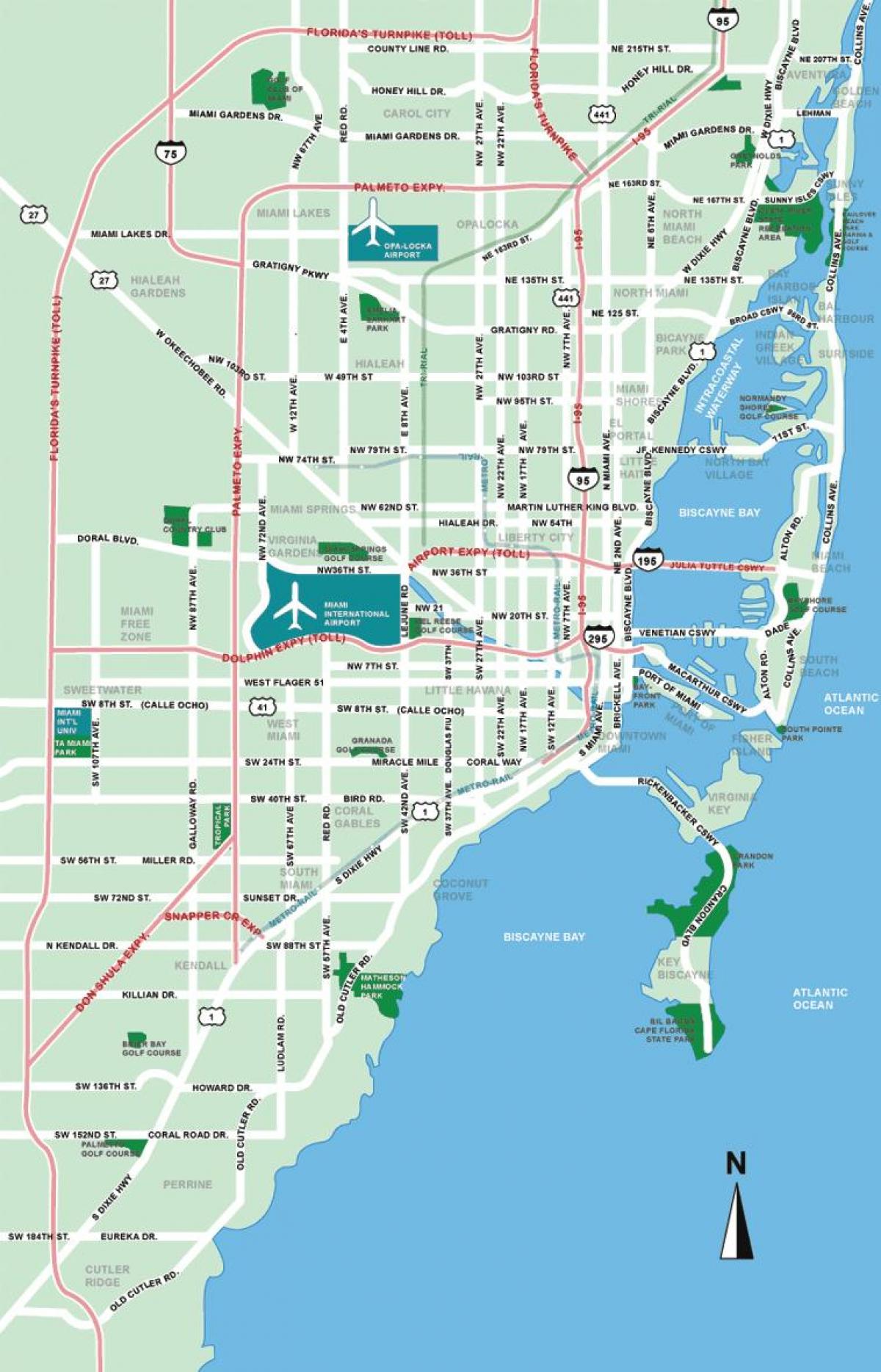
Miami on Florida - USA map shows the location of the city of Miami on the Florida - USA map. This map of Miami in Florida - USA will allow you to easily plan your travel in Miami in Florida - USA. Miami on map of Florida - USA is downloadable in PDF, printable and free.
Miami (play /maɪˈæmi/ or /maɪˈæmə/) is a city located on the Atlantic coast in southeastern Florida and the county seat of Miami-Dade County, the most populous county in Florida and the eighth-most populous county in the USA with a population of 2,500,625 as its shown in Miami Florida-USA map. The 42nd largest city proper in the United States, with a population of 408,568, it is the principal, central, and most populous city of the South Florida metropolitan area, and the most populous metropolis in the Southeastern United States. According to the US Census Bureau, Miami metro area is the seventh most populous and fifth-largest urban area in the United States, with a population of around 5.5 million. According to the U.S. Census Bureau, in 2004, Miami had the third highest incidence of family incomes below the federal poverty line in the USA, making it the third poorest city in the USA, behind only Detroit, Michigan (ranked #1) and El Paso, Texas (ranked #2).
In 2010, Miami ranked seventh in the USA in terms of finance, commerce, culture, entertainment, fashion, education, and other sectors. It ranked thirty-third among global cities as its mentioned in Miami Florida - USA map. In 2008, Forbes magazine ranked Miami "America Cleanest City", for its year-round good air quality, vast green spaces, clean drinking water, clean streets and city-wide recycling programs. According to a 2009 UBS study of 73 world cities, Miami was ranked as the richest city in the USA. Downtown Miami and South Florida are home to the largest concentration of international banks in the United States. As of 2011, the Port of Miami accounts for 176,000 jobs and has an annual economic impact in Miami of $18 billion. It is the 11th-largest cargo container port in the United States. In 2010, a record 4.33 million passengers traveled through the Port of Miami.
In terms of land area, Miami is one of the smallest major cities in the USA. According to the US Census Bureau, the city encompasses a total area of 55.27 sq mi (143.1 km2). Of that area, 35.67 sq mi (92.4 km2) is land and 19.59 sq mi (50.7 km2) is water. That means Miami comprises over 400,000 people in a mere 35 square miles (91 km2), making it one of the most densely populated cities in the United States, along with New York City, San Francisco, and Chicago among others. Miami is located at 25°47′16″N 80°13′27″W / 25.78778°N 80.22417°W as you can see in Miami Florida - USA map. Miami is the twelfth largest radio market and the seventeenth largest television market in the United States. In 2011, Forbes Magazine named Miami the second most miserable city in the United States due to its high foreclosure rate and past decade of corruption among public officials. In 2012, Forbes Magazine named Miami the most miserable city in the USA because of a crippling housing crisis that has cost multitudes of residents their homes and jobs.

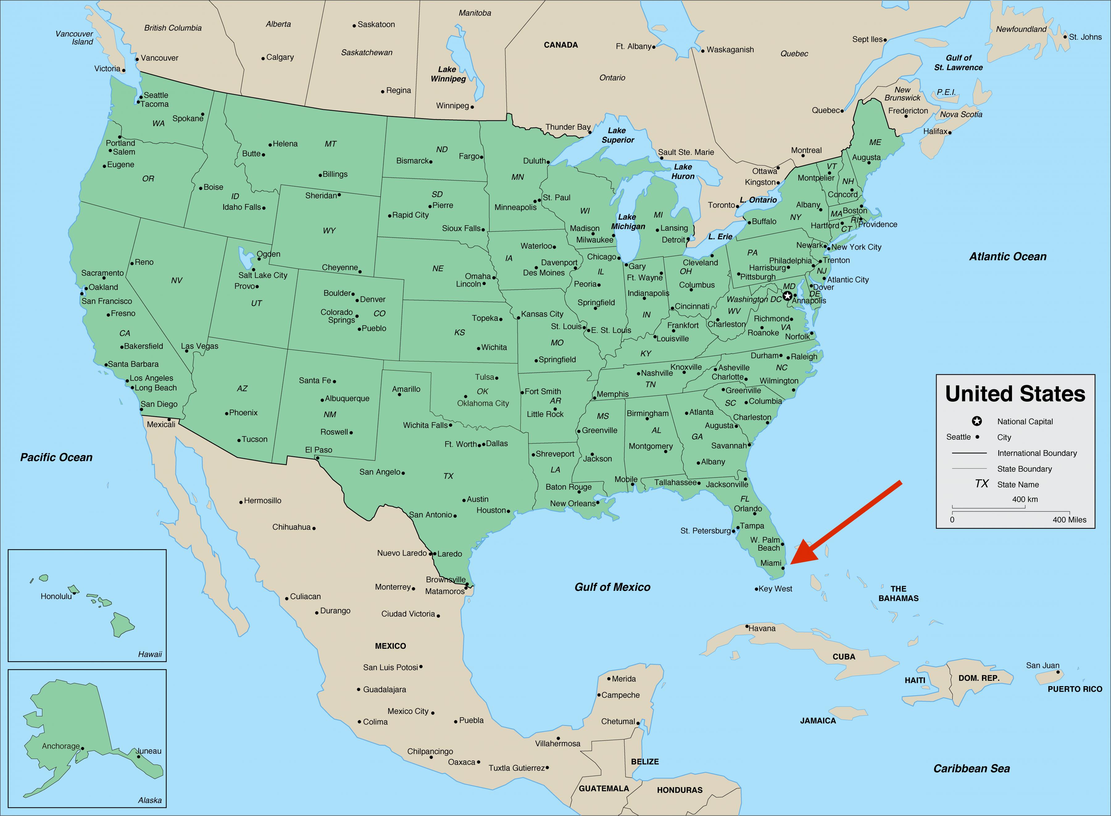
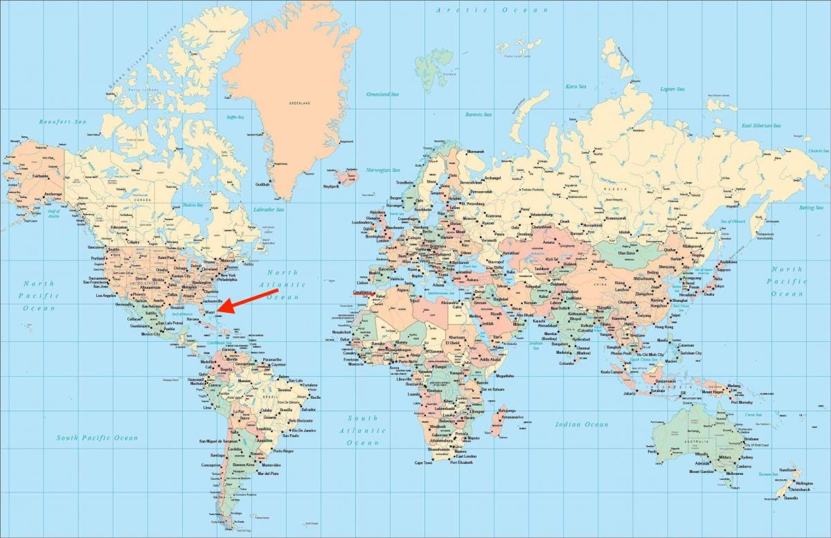
Miami on world map shows the location of the city of Miami in the world. Miami on world map will allow you to easily know where is Miami in the world. The Miami in world map is downloadable in PDF, printable and free.
In 2010, Miami was classified as a Alpha- World City in the World Cities Study Group inventory. In 2010, Miami ranked seventh in the United States in terms of finance, commerce, culture, entertainment, fashion, education, and other sectors. It ranked thirty-third among global cities. In 2008, Forbes magazine ranked Miami "America Cleanest City", for its year-round good air quality, vast green spaces, clean drinking water, clean streets and city-wide recycling programs. According to a 2009 UBS study of 73 world cities, Miami was ranked as the richest city in the United States, and the world fifth-richest city in terms of purchasing power as its mentioned in Miami on world map. Miami is nicknamed the "Capital of Latin America", is the 2nd largest U.S. city (after El Paso) with a Spanish-speaking majority, and the largest city with a Cuban-American plurality.
For more than two decades, the Port of Miami, known as the "Cruise Capital of the World," has been the number one cruise passenger port in the world, accommodating some of the world largest cruise ships and operations, and is currently the busiest in both passenger traffic and cruise lines. Miami is a major center of commerce, finance, and boasts a strong international business community (see Miami on world map). According to the ranking of world cities undertaken by the Globalization and World Cities Study Group & Network (GaWC) and based on the level of presence of global corporate service organizations, Miami is considered a "Beta− world city". Miami has a Gross Metropolitan Product of $257 billion and is ranked 20th worldwide in GMP, and 11th in the United States.
In a 2009 UBS study of 73 world cities, Miami was ranked as the richest city in the United States (of four U.S. cities included in the survey) and the world fifth-richest city, in terms of purchasing power. Miami has the world largest amount of cruise line headquarters, home to: Carnival Cruise Lines, Celebrity Cruises, Norwegian Cruise Line, Oceania Cruises, and Royal Caribbean International as you can see in Miami on world map. On May 24, 2010, construction began on the $1 billion Miami port tunnel that will serve the Port of Miami. The port of Miami is the largest cruise ship port in the world. The port is often called the "Cruise Capital of the World" and the "Cargo Gateway of the Americas". It has retained its status as the number one cruise/passenger port in the world for well over a decade accommodating the largest cruise ships and the major cruise lines.